Friday, May 22, 2009

ArcPad Tips & Tricks #5: Choosing the correct image format

ArcPad supports a number of different image formats, including BMP, GIF, JPEG, PNG, TIFF and ECW (note that you require a 3rd party extension to use ECW images). But how do these differ? And which one should you use? There are a couple of good summaries on the ArcPad Team Blog which should help you get started.

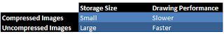
The long and the short of the matter is you have to make a compromise between image file size and drawing performance. Obviously, the larger the image is, the more storage you need available on your device to save the image. If storage is an issue, then it is worth looking at one of the compressed image formats, such as JPEG or ECW.


Whilst compressed images save on storage, they do require more overhead when viewing in the map. ArcPad must decompress and interpret the image, as you pan and zoom around the map, resulting in poorer performance. This is of particular importance in ArcPad 8, given some of the memory issues that users have been facing.


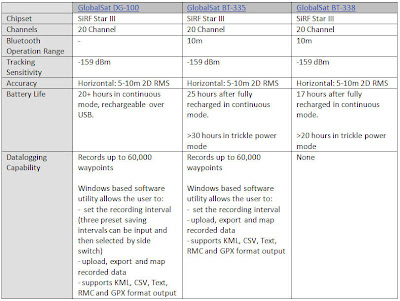
In very simplistic terms, the following table summarises the differences:


For more information, refer to the ArcPad Team Blog articles.

Thursday, May 21, 2009

ArcPad - A Field Users Guide

ESRI have a great additional ArcPad Resource on their site.

For guidance on how to use ArcPad in your field GIS project, take a look at Johnathan Raper’s, PDF ebook, 'ArcPad A Field User’s Guide'.

The book can be found here.

Please note that the book is based on a previous version of ArcPad, however the components and principles as discussed in the book are still valid.

Wednesday, May 6, 2009

ArcPad Tips & Tricks #4: Optimising Streetmap Extension

We have had a few enquiries from customers using the Streetmap Extension with ArcPad 8. On some PDA's, they are unable to add the streetmap data to a map that already has layers in it. If the map is empty, then there are no issues. To confuse things further, it all loaded fine on the desktop version of ArcPad.

After a bit of investigation, it turned out that the cause of the problem was memory constraints. The only way that we could get the data to load was to turn off all extensions that were not being used. Once we had ArcPad down to the bare bones state, the data loaded up fine, and the extension could be used.

So, to turn the extensions off:

  1. From the Options menu, select Utilities à Advanced Settings
  2. Switch to the Extensions menu
  3. Uncheck all extensions that you are not using. By default, a lot of these will be already turned off. There should be some (such as the graphics layer and photo layer) that you can also turn off.
  4. Restart ArcPad (this is important, as the changed settings are not applied until you restart).

If you are still having problems, then you may need to clip a subset of the streetmap data to restrict the amount of data in the map.

Tuesday, May 5, 2009

ArcPad Tips & Tricks #3: Related Table Support

There has been a little bit of confusion from some of our clients surrounding the support of related tables within ArcPad, using the AXF file format. Here are some basic rules which should help to clear things up:

  1. One-to-many, and one-to-one relationships are supported. Many-to-many are not.
  2. Related tables must be just that, tables, and not feature classes.
  3. The parent in the relationship must be a feature class (point, line or polygon). This is in keeping with the map-centric focus of ArcPad, where all editing is done via the map.
  4. You can relate as many tables to the base feature class as you like.
  5. You must have a Geodatabase relationship class set up in order for a related table to be exported. Any joins or relates that you set up within your ArcMap mxd document will not be exported.

Related tables are an extremely useful tool to have out in the field, as they eliminate the need to duplicate spatial features that define the same location in space. For example, you may have a tree / inspection (one-to-many) scenario. Without related tables, each time you do an inspection, the location of the tree would have to be recaptured, when in fact it probably hasn't moved. Over a period of time, you will end up with a whole heap of points stacked on top of one another. With related tables, you would only collect one point – that on the initial inspection. From then on, only tabular data is collected. This leads to significant performance improvements also, as fewer features have to be drawn.

Tuesday, April 28, 2009

GPS and Geotagging Images

Hardware such as the RICOH Caplio cameras with an integrated GPS Module are still a popular option for capturing images with location-specific information. However, emerging trends in the marketplace have called for cheaper options for users to capture images with a spatial location, in particular for the travelling masses.

On a recent trip to the Southwest National Park in Tasmania, I tested the GlobalSat BT-335 GPS and used it in a datalogging capacity. By simply synchronising the time on your camera with the time set on the GPS unit, it is possible to automatically geotag your images with location information when you arrive back in the office. After downloading the GPS Tracklog data from the GPS and the captured photos to the PC, the free Geotagging facility LOCR was used to automatically geotag my photos taken on the walk with the GPS coordinates logged with the GlobalSat BT-335 GPS.

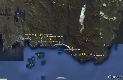
At a click of a button you can also view your photo points in Google Earth.

The BT-335 proved to be a reliable option for capturing GPS information to be linked with captured images. With 25 hours of battery life and a capacity to be used as either a stock standard Bluetooth GPS or a datalogger, the BT-335 is a great GPS option for fieldwork and travel alike.

Friday, April 24, 2009

ArcPad 8 Released in Australia

ArcPad 8 has been released in Australia as of Monday 20th April.

A bonus for users is that you can still choose between Version 7.1.1 and Version 8 for their ArcPad purchases.

The inclusion of ArcPad Studio (the development framework to customize ArcPad) as standard with ArcPad 8 licences is good news to budding developers out there. For a list of 'Whats new in ArcPad 8', see: http://www.esri.com/software/arcgis/arcpad/whats_new.html

Thursday, April 16, 2009

GPS Comparison: GlobalSat DG-100, BT-338 and BT-335

The GlobalSat BT-338 has been a popular and reliable performer in the GPS marketplace since 2005. With the release of the GlobalSat BT-335 GPS in late 2007, the datalogging capability has been added to the GlobalSat Bluetooth GPS range. The BT335 model can be utilised as either a stock standard Bluetooth GPS or as a datalogger. In addition to the Datalogging capability, the BT335 has increased battery life as compared to the BT338.

There is still the GlobalSat DG-100 USB Datalogging GPS for users who don’t require or want a GPS with Bluetooth capabilities. Below is a table outlining the basic specifications of the respective GlobalSat units.


PDA Comparison: iPaq 2790 and iPaq 212

Since its release in 2005, the IPAQ 2790 has been one of the most popular PDA units utilised in the field of Mobile GIS. In late 2007 the IPAQ 200 series was released, which has reverted to a style similar to that of previous IPAQ versions such as the IPAQ 4700 series.


Below is a table summarising the differences between the respective units. Some users are still opting for the proven 2790 over the 212 model, but the slight improvements in the 212 specifications and the fact that the 212 is the newer product generally tips the balance in its favour.


Wednesday, April 8, 2009

ArcPad 8 Released in the US

ArcPad 8 was officially released in the US over night.

Interestingly, you can buy both ArcPad 7.1.1 and ArcPad 8 from the online store.

Stay tuned for the release in Australia!

Thursday, April 2, 2009

Configuring ArcPad Tools for ArcToolbox

There are several ArcToolbox tools available to assist in the process of checking data out of your Geodatabase for use in ArcPad, and then back in. If you have ArcGIS installed before installing ArcPad, these will automatically appear in the list of Favourites in ArcToolbox, Under "ArcPad Tools".

If you don't have ArcGIS installed, then this will be of no help.

If you don't have ArcGIS installed (when you install ArcPad), you will need to manually add this toolbox to your favourites:

  1. Copy "ArcPad Tools.tbx" from the "C:\Program Files\ArcPad X.X\Desktop Tools" folder.
  2. Paste it to "C:\Program Files\ArcGIS\ArcToolbox\Toolboxes"
  3. Open ArcToolbox (in either ArcMap or ArcCatalog)
  4. Right click the ArcToolbox node, and select "Add Toolbox..."
  5. Navigate to "C:\Program Files\ArcGIS\ArcToolbox\Toolboxes"
  6. Select "ArcPad Tools.tbx". You should see the toolbox added to your favourites.
  7. To save them there permanently, right click the ArcToolbox node and select Save Settings à To Default

There are also a set of custom check out tools provided by the ArcPad development team. These tools allow you to copy layer definitions and scripts from one AXF to another. To configure these tools:

  1. Download the AXFCopy tool from ArcScripts.
  2. Copy the extracted files to C:\Program Files\ArcPad 7.1\Desktop Tools\Samples\AXFCopy
  3. Download and install the Microsoft Visual C++ 2008 Redistributable Package
  4. Repeat the above process to add these tools to your favourites menu

RIA Mobile GIS has implemented a number of data synchronisation tools utilising these Geoprocessing tools. If you would like any further information, do not hesitate to contact us.

Monday, March 30, 2009

ArcPad Tips & Tricks #2: Multiple layer definitions

Did you know that the AXF file format supports multiple layer definitions for a single feature class? This works in the same way as Layer files in ArcMap: the layer defines the symbology, which points to a feature class, which stores all of the data (both spatial and attributes). To set this up in ArcPad:
  1. Open the AXF in ArcPad studio
  2. Expand the Feature Tables node
  3. Right click on the table you wish to create the layer definition for, and select "Create New Layer". A new layer definition is added to the Feature Layers node
  4. You can rename the layer to whatever you like

And how is this useful I hear you ask. Well, a couple of ideas are:

  1. You could create different edit forms for different purposes. For example, you may have a layer for new features that are collected, and one for follow up inspections. You can specify different forms to ensure the correct fields are filled out in each inspection.
  2. You can combine the layer definitions with filters to create more complex symbology. For example, you may wish to categorise your roads layer into suburban roads, major roads and highways, and display them at different zoom scales.

Wednesday, March 25, 2009

ArcPad Tips & Tricks #1: Layer Icons


Did you know that you can set icons for your layers. These will appear in the Table of Contents and the Edit drop down menu, making it easier to differentiate between your layers.


For shapefiles, all you need to do is copy a .ico file, with the same base name as the shapefile, into the same directory. So, for example, if your shapefile is Roads.shp, name you .ico file Roads.ico.

The process is a bit more complicated with AXF files. You need to open up the axf in Application Builder, right click the layer and select "Set Layer Icon". You can clear the icon by selecting "Clear Layer Icon".

A good selection of sample icons can be found in C:\Program Files\ArcPad 7.1\Samples\Layer Icons. If you want to make your own, a good program is IcoFX. Your icons need to be 4bit 16x16 images.

Tuesday, March 17, 2009

Behind the Scenes Technical Assistance

In the wake of the recent Victorian Bushfires, behind the scenes, staff from RIA Mobile GIS have been providing technical assistance to MapTel, to support the Victorian Police Search and Rescue efforts.

For further information read the post ArcPad 8 - Victorian Bushfires 2009 on the MapTel Blog.

Monday, March 16, 2009

Mobile GIS Image Capture

There are a number of different hardware options to choose between for image capture within your Mobile GIS System. The competing priorities of specifications, cost and usability are balanced to determine the choice made by the user. Here is a table listing some of the typical units used for Mobile GIS applications and their respective camera specifications:


IPAQ 612c Business Messenger
· Reasonably priced non-rugged unit with PDA/GPS/Phone, suited to users requiring an all inclusive device.
· Typical applications include
Asset Management: recording and monitoring assets in urban streetscapes

TDS Nomad 800LC*
· Rugged (IP67 rating) all inclusive PDA/GPS/Camera unit with long battery life, suited for tough outdoor environments
· Typical applications include
Asset Management: street/pavement inspection, maintenance and repairs
Environmental Monitoring: Tree inventories, pest control, weed management

* Now also available in the 800XC model, which includes all the 800LC specifications in addition to GPRS and 2GB Flash Storage. Contact RIA Mobile GIS for more information.

RICOH Caplio 500SEW Camera
· Rugged (IP67 rating), stand alone camera that can be utilised for a wide range of applications. BT/WiFi included, allowing easy connection to your Mobile GIS System and transfer of images in the field. RICOH clip on GPS module or Digital compass/GPS module also available. Includes CALS mode which has default settings where captured images are suitable to be submitted for official public works.
· Typical applications include
Asset management: Construction/Engineering firms recording images of defects
Insurance Companies: Image records for insurance claims

Friday, March 6, 2009

RIA Mobile GIS Expands Training Courses

RIA Mobile GIS now offers an expanded range of Training Courses.

These courses are designed to assist organisations and users achieve the most from their Field Project. The courses are designed to encompass both the Field and Office (Desktop) components of a field based project as well as cover the integration between these components.

The Mobile/Field based courses are:

  • Using ArcPad - 1 day course providing a functional overview and hands on experience using ArcPad and associated hardware.
  • ArcPad Application Builder - 1 day course providing a functional overview of how ArcPad Studio can be used to customise ArcPad and extend its’ capabilities.

RIA Mobile GIS is an ESRI accredited trainer authorised to provide ArcPad training courses. We are the developers of the ArcPad and ArcPad Application Builder courses run throughout Australia and New Zealand.

The Desktop/Office based courses are:

  • Introduction to ArcGIS - 2 day robust course providing a conceptual overview and hands-on experience using ArcGIS Desktop software.
  • Using GeoDatabases - 1 day course providing an overview and hands-on experience using the ArcGIS GeoDatabase format.

All Courses are offered as either Standard Scheduled Courses, or Client Requested Onsite Courses.

Please note that our training options will be further expanded, updated and refined over the coming months with the impending release of ArcPad 8, which is due out shortly.