Friday, February 27, 2009

ArcPad 8 is on its way!


ESRI has announced that ArcPad 8 will be released in the first quater of 2009. The new version will see an entirely revamped user interface, featureing an Office 2007 type feel with ribbons and quick launch toolbars. As a bonus, ArcPad Application Builder, the development framework for ArcPad, will be included with every ArcPad 8 license.

Other highlights of the new release include:
  • An ArcGIS Server Extension to allow direct synchronisation to ArcGIS Server from ArcPad
  • An improved, more intuitive GPS interface that takes up less screen real estate
  • An enhanced ArcPad Data Manager Extension, which will simplify the process of checking data out and in of the Geodatabase.
If you have any questions at all about the new release, training (for both ArcPad and Application Builder), give us a call on 03 6223 4919.


Stay tuned for further updates regarding the release date and pricing structure.
Friday, February 6, 2009

Mobile Printing


Printing from a PDA usually meant connecting it to a desktop PC and sending files to the local printer. This meant it was hard when you are out in the field.

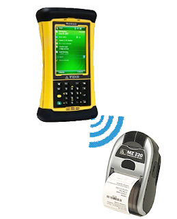
We have been testing with a Zebra mobile printer with great success. You can print directly from ArcPad to a printer which is small enough to fit on your belt. These types of printers are great for receipts, barcode or reports. You could have an inspection receipt containing data you have just collected to leave with the landholder or print custom reports with barcodes to aid with evidence collection while in the field. The list of possibility is endless.

The downside to this is the print area, the one we currently have uses a 2 inch thermal roll (similar to a fax machine), but there are wider ones available. It is powered by a Lithium-Ion rechargeable battery and utilises Bluetooth for communications. You can find more information at the Zebra MZ-220 here.


Please contact RIA Mobile GIS for further information on how to integrate mobile printing into your Mobile GIS system.