Showing posts with label Mobile GIS. Show all posts

Wednesday, July 6, 2011

We are now mobile & spatially enabled!

What are two things that you think of when someone says mobile GIS? To me, it is pretty obvious... mobile, and spatial. Well guess what, our Mobile GIS blog is now both mobile and spatial. Hooray!

Take a look at out blog from your mobile device. Very pretty!

I have also started defining the location of the blogs. What this means, I don't really know, but I have done it anyway :)

Tuesday, February 22, 2011

Mobile GIS Hardware Review

After several inquiries, a document was prepared in order to provide a clear and concise overview of the most popular units used in the field for mobile GIS applications. It covers a wide range of units, from standard PDAs through to ruggedised laptops, and different brands such as Nomad, GeTac, Panasonic and Xplore. Units have been arranged into classes according to the kind of detailed data they are able to capture. The document also includes approximate prices.
Hopefully this will be a good starting point for people trying to research the best mobile GIS solution for them!
If you would like the PDF, please email me at Patrick@riamobilegis.com.au

Thursday, December 23, 2010

Height Enabling ArcPad

Height enabling features (i.e. collecting 3D x,y,z positions) in ArcPad is simple. You just need to make sure that you have (1) your data set up correctly; and (2) correctly configure your hardware.

Configuring your data
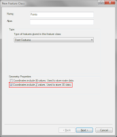
When creating a shapefile or feature class, you must specify that you want to z enable it. From within ArcGIS, this is simply a matter of selecting the "Coordinates include Z values. Used to store 3D data" option on the first page of the "Create new feature class" dialog.
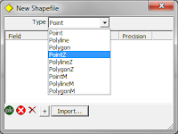
In ArcPad, when creating a new shapefile, you should select the feature type as "PointZ".

Unfortunately, there is no way of z enabling a pre-existing, non z enabled feature class. You must create a new one, import the fields from your previous feature class, then import all of the features across. In this case, any features already captured will not have valid z values. You will need to update these.

Any features from these datasets that are collected within ArcPad will automatically be assigned a z height value at the time of creation. If you digitise a point, a z height of 0 will be assigned. You can easily change this value manually via the geometry page of the edit form if required. If you capture the features using a GPS or laser rangefinder, then provided they are configured correctly to output height coordinates, then these will automatically be assigned to the feature.

Configuring your hardware
This part will probably either be very easy, or a little bit tricky. Basically what you want to do is to make sure that whatever hardware you are using (GPS, laser rangefinder) is outputing data that includes height information. Most GPS units will do this by default. So unless you have gone in to your GPS and altered the messages that are being sent from it, you should be pretty right. If you have played around with the GPS, you will need to dig out your manual and make sure that the height information is being exported correctly.

With laser rangefinders, it should be as simple as making sure that some form of height measurement is being read and exported to ArcPad. For example, you should read the slope distance and inclination to the target. If you export only the bearing and the horizontal distance, then ArcPad has no way of knowing what the change in height from your position to the target actually is.

Accessing the height information
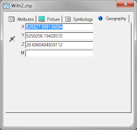
Accessing the height of your points from within ArcPad is also simple. When you create or edit a point, you can switch to the Geography page, which will show the coordinates of the point (including the z height). If you have a line or a polygon layer, it will list all of the coordinates of all of the vertices of that feature.
You can do the same when identifying a feature.

From within ArcGIS, it is not quite so simple. You must add the feature class to ArcMap, start an edit session, use the Edit Tool from the Editor toolbar (the black arrow), double click the point, then open the "Edit Sketch Properties" window. This will list the X, Y, Z coordinates of the selected point (or vertices of a line or polygon).

Another way of viewing this information is to add a float (or double) field to the feature class, then use the "Calculate Geometry" tool in the table view in ArcMap, to calculate the z coordinates of each feature and store that to a field.

Wednesday, August 4, 2010

Getac E100A Tablet Release


For Mobile GIS users interested in tablet technology, the Getac presents an update on the E100 tablet, the E100A.
The E100A has substantially increased the E100 memory components; doubling the processor from 800MHz to 1.66 GHz,upsizing from 1GB RAM to 2GB RAM and the previous Hard Disk Drive is now a 80GB Solid State Drive.
Manufacturer confidence in the Getac product is shown in the 5 year standard warranty. The E100A will be available soon, contact us for more information.

Thursday, July 29, 2010

ESRI Mobile GIS Offerings

To clarify the current the ESRI Mobile GIS product offerings are:
  • ArcPad - ArcPad 10 is designed for Windows and Windows Mobile devices.
  • ArcGIS Mobile - ArcGIS Mobile 10 is for Windows and Windows Mobile devices.
  • ArcGIS for iOS - Apple iOS devices - iPod (Touch), iPhone and iPad.
  • ArcGIS for Windows Phone (Under Development) - Windows Phone 7 Devices.
  • ArcGIS for Android (Under Development, according to the UC 2010 Q&A) - Android OS devices - Smart Phones other Android devices.

Friday, July 2, 2010

Mobile GIS & Spatial Trends

Technology appears to be evolving at an ever increasing rate, and this is enabling a number of interesting developments.
I'll endeavour to write a series of posts highlighting some of these trends and developments, as they relate to the Mobile Technology, ESRI Software and Spatial arenas.
(The frequency of these posts will depend somewhat on when time permits!)

In the interim, an insight into where ESRI is heading, is the annual ESRI UC Preconference Q&A. Take a look, some of your questions may be answered.

Monday, March 16, 2009

Mobile GIS Image Capture

There are a number of different hardware options to choose between for image capture within your Mobile GIS System. The competing priorities of specifications, cost and usability are balanced to determine the choice made by the user. Here is a table listing some of the typical units used for Mobile GIS applications and their respective camera specifications:


IPAQ 612c Business Messenger
· Reasonably priced non-rugged unit with PDA/GPS/Phone, suited to users requiring an all inclusive device.
· Typical applications include
Asset Management: recording and monitoring assets in urban streetscapes

TDS Nomad 800LC*
· Rugged (IP67 rating) all inclusive PDA/GPS/Camera unit with long battery life, suited for tough outdoor environments
· Typical applications include
Asset Management: street/pavement inspection, maintenance and repairs
Environmental Monitoring: Tree inventories, pest control, weed management

* Now also available in the 800XC model, which includes all the 800LC specifications in addition to GPRS and 2GB Flash Storage. Contact RIA Mobile GIS for more information.

RICOH Caplio 500SEW Camera
· Rugged (IP67 rating), stand alone camera that can be utilised for a wide range of applications. BT/WiFi included, allowing easy connection to your Mobile GIS System and transfer of images in the field. RICOH clip on GPS module or Digital compass/GPS module also available. Includes CALS mode which has default settings where captured images are suitable to be submitted for official public works.
· Typical applications include
Asset management: Construction/Engineering firms recording images of defects
Insurance Companies: Image records for insurance claims

Friday, February 27, 2009

ArcPad 8 is on its way!


ESRI has announced that ArcPad 8 will be released in the first quater of 2009. The new version will see an entirely revamped user interface, featureing an Office 2007 type feel with ribbons and quick launch toolbars. As a bonus, ArcPad Application Builder, the development framework for ArcPad, will be included with every ArcPad 8 license.

Other highlights of the new release include:
  • An ArcGIS Server Extension to allow direct synchronisation to ArcGIS Server from ArcPad
  • An improved, more intuitive GPS interface that takes up less screen real estate
  • An enhanced ArcPad Data Manager Extension, which will simplify the process of checking data out and in of the Geodatabase.
If you have any questions at all about the new release, training (for both ArcPad and Application Builder), give us a call on 03 6223 4919.


Stay tuned for further updates regarding the release date and pricing structure.