Tuesday, April 28, 2009

GPS and Geotagging Images

Hardware such as the RICOH Caplio cameras with an integrated GPS Module are still a popular option for capturing images with location-specific information. However, emerging trends in the marketplace have called for cheaper options for users to capture images with a spatial location, in particular for the travelling masses.

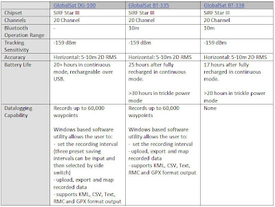
On a recent trip to the Southwest National Park in Tasmania, I tested the GlobalSat BT-335 GPS and used it in a datalogging capacity. By simply synchronising the time on your camera with the time set on the GPS unit, it is possible to automatically geotag your images with location information when you arrive back in the office. After downloading the GPS Tracklog data from the GPS and the captured photos to the PC, the free Geotagging facility LOCR was used to automatically geotag my photos taken on the walk with the GPS coordinates logged with the GlobalSat BT-335 GPS.

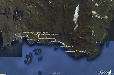
At a click of a button you can also view your photo points in Google Earth.

The BT-335 proved to be a reliable option for capturing GPS information to be linked with captured images. With 25 hours of battery life and a capacity to be used as either a stock standard Bluetooth GPS or a datalogger, the BT-335 is a great GPS option for fieldwork and travel alike.

Friday, April 24, 2009

ArcPad 8 Released in Australia

ArcPad 8 has been released in Australia as of Monday 20th April.

A bonus for users is that you can still choose between Version 7.1.1 and Version 8 for their ArcPad purchases.

The inclusion of ArcPad Studio (the development framework to customize ArcPad) as standard with ArcPad 8 licences is good news to budding developers out there. For a list of 'Whats new in ArcPad 8', see: http://www.esri.com/software/arcgis/arcpad/whats_new.html

Thursday, April 16, 2009

GPS Comparison: GlobalSat DG-100, BT-338 and BT-335

The GlobalSat BT-338 has been a popular and reliable performer in the GPS marketplace since 2005. With the release of the GlobalSat BT-335 GPS in late 2007, the datalogging capability has been added to the GlobalSat Bluetooth GPS range. The BT335 model can be utilised as either a stock standard Bluetooth GPS or as a datalogger. In addition to the Datalogging capability, the BT335 has increased battery life as compared to the BT338.

There is still the GlobalSat DG-100 USB Datalogging GPS for users who don’t require or want a GPS with Bluetooth capabilities. Below is a table outlining the basic specifications of the respective GlobalSat units.


PDA Comparison: iPaq 2790 and iPaq 212

Since its release in 2005, the IPAQ 2790 has been one of the most popular PDA units utilised in the field of Mobile GIS. In late 2007 the IPAQ 200 series was released, which has reverted to a style similar to that of previous IPAQ versions such as the IPAQ 4700 series.


Below is a table summarising the differences between the respective units. Some users are still opting for the proven 2790 over the 212 model, but the slight improvements in the 212 specifications and the fact that the 212 is the newer product generally tips the balance in its favour.


Wednesday, April 8, 2009

ArcPad 8 Released in the US

ArcPad 8 was officially released in the US over night.

Interestingly, you can buy both ArcPad 7.1.1 and ArcPad 8 from the online store.

Stay tuned for the release in Australia!

Thursday, April 2, 2009

Configuring ArcPad Tools for ArcToolbox

There are several ArcToolbox tools available to assist in the process of checking data out of your Geodatabase for use in ArcPad, and then back in. If you have ArcGIS installed before installing ArcPad, these will automatically appear in the list of Favourites in ArcToolbox, Under "ArcPad Tools".

If you don't have ArcGIS installed, then this will be of no help.

If you don't have ArcGIS installed (when you install ArcPad), you will need to manually add this toolbox to your favourites:

  1. Copy "ArcPad Tools.tbx" from the "C:\Program Files\ArcPad X.X\Desktop Tools" folder.
  2. Paste it to "C:\Program Files\ArcGIS\ArcToolbox\Toolboxes"
  3. Open ArcToolbox (in either ArcMap or ArcCatalog)
  4. Right click the ArcToolbox node, and select "Add Toolbox..."
  5. Navigate to "C:\Program Files\ArcGIS\ArcToolbox\Toolboxes"
  6. Select "ArcPad Tools.tbx". You should see the toolbox added to your favourites.
  7. To save them there permanently, right click the ArcToolbox node and select Save Settings à To Default

There are also a set of custom check out tools provided by the ArcPad development team. These tools allow you to copy layer definitions and scripts from one AXF to another. To configure these tools:

  1. Download the AXFCopy tool from ArcScripts.
  2. Copy the extracted files to C:\Program Files\ArcPad 7.1\Desktop Tools\Samples\AXFCopy
  3. Download and install the Microsoft Visual C++ 2008 Redistributable Package
  4. Repeat the above process to add these tools to your favourites menu

RIA Mobile GIS has implemented a number of data synchronisation tools utilising these Geoprocessing tools. If you would like any further information, do not hesitate to contact us.