On a recent trip to the Southwest National Park in Tasmania, I tested the GlobalSat BT-335 GPS and used it in a datalogging capacity. By simply synchronising the time on your camera with the time set on the GPS unit, it is possible to automatically geotag your images with location information when you arrive back in the office. After downloading the GPS Tracklog data from the GPS and the captured photos to the PC, the free Geotagging facility LOCR was used to automatically geotag my photos taken on the walk with the GPS coordinates logged with the GlobalSat BT-335 GPS.
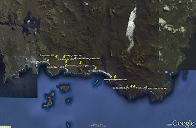
 At a click of a button you can also view your photo points in Google Earth.
The BT-335 proved to be a reliable option for capturing GPS information to be linked with captured images. With 25 hours of battery life and a capacity to be used as either a stock standard Bluetooth GPS or a datalogger, the BT-335 is a great GPS option for fieldwork and travel alike.
4 comments:
my trimble nomad can take geotagged pics with it's built in camera. It can be a photo layer or have the picture file name in the attribute table, but ArcMap does cannot seem to display the photo. Here's my beef with this, I have taken all these Geotagged photos and now they don't display in ArcMap? Sure, they pop up in google earth, but then I have to export my shape file to kml just to see the photos associated w/my points? I can see the photo file name in the attribute table while in ArcMap but not the actual pics????
Are there other alternatives to get the geotagged pics already associated w/my shapefiles to display in ArcMap?I found a thread on the ESRI website regarding an applet but i can't get it to work. Here is the link
http://forums.esri.com/Thread.asp?c=34&f=2133&t=197608
Hi Luke, I tried the applet too, but without any luck. The error i got was "Buffer overrun detected!". Is that what you got too?
The easiest way that i have found is to extract the coordinates from the photos, generate a shapefile, and store the photo name as a field in the shapefile. You can then use the hyperlink or html popup tools to display the photos in ArcMap.
If you are interested, we have a desktop tool which extracts coordinates from the EXIF header of photos, and exports to a csv file. It costs $49 AUD. Let me know if you are interested.
More information on the Photo Extractor tool can be found here
Thanks Luke, that makes me feel a little less GIS inept if you could not get that applet to work either. I will try your tips and give you an update.
Post a Comment