If you don't have ArcGIS installed, then this will be of no help.
If you don't have ArcGIS installed (when you install ArcPad), you will need to manually add this toolbox to your favourites:
- Copy "ArcPad Tools.tbx" from the "C:\Program Files\ArcPad X.X\Desktop Tools" folder.
- Paste it to "C:\Program Files\ArcGIS\ArcToolbox\Toolboxes"
- Open ArcToolbox (in either ArcMap or ArcCatalog)
- Right click the ArcToolbox node, and select "Add Toolbox..."
- Navigate to "C:\Program Files\ArcGIS\ArcToolbox\Toolboxes"
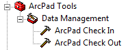
- Select "ArcPad Tools.tbx". You should see the toolbox added to your favourites.
- To save them there permanently, right click the ArcToolbox node and select Save Settings à To Default
There are also a set of custom check out tools provided by the ArcPad development team. These tools allow you to copy layer definitions and scripts from one AXF to another. To configure these tools:
- Download the AXFCopy tool from ArcScripts.
- Copy the extracted files to C:\Program Files\ArcPad 7.1\Desktop Tools\Samples\AXFCopy
- Download and install the Microsoft Visual C++ 2008 Redistributable Package
- Repeat the above process to add these tools to your favourites menu
RIA Mobile GIS has implemented a number of data synchronisation tools utilising these Geoprocessing tools. If you would like any further information, do not hesitate to contact us.
3 comments:
Thanks for the post, very clear instructions.
Thanks Luke, glad i could help. Out of interest, are you using ArcToolbox at all for your ArcPad applications?
Are there any other topics that you would like us to blog about?
I am trying to figure out how to do that. I have a invasive weed shapefile with certain attributes I want to capture.
Other topics would be photo layers. I have a nomad w/camera and can take pics but not display them in ArcMap.
Post a Comment