Thursday, December 23, 2010
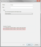
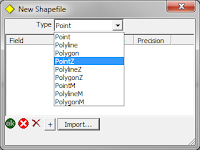
Height Enabling ArcPad
Monday, November 22, 2010
ArcGIS & ArcPad 10 SP 1
Wednesday, August 18, 2010
ArcPad Data Manager Toolbar: Select Picture Options (ArcGIS 10)
When field data and photos have been collected in the field and then imported back into the ArcGIS/office environment using the Get Data from ArcPad (Check In) tool, the Picture field(s) are populated using the predefined folder location for Pictures and the name of the image (e.g. D:\MyPhotos\Pictures_0001.jpg).
When identifying a point in ArcMap, the ArcGIS 10 dialog lists the point attributes, with the hyperlink function automatically enabled for Picture fields where an image exists. The user can simply click on the Picture field path and the image will be displayed on screen.
Monday, August 16, 2010
ArcPad Check Out Problems
- Open the AXF in Studio
- Start a command window
- Copy the SQL statement below, paste it into the window and execute it.
Monday, August 9, 2010
Application Builder Training - Melbourne - 11 November
Wednesday, August 4, 2010
Getac E100A Tablet Release
ArcPad 10 Training - Perth
The popular Using ArcPad training course has been scheduled for Wednesday the 22nd of September in Perth.
Further information on the course can be viewed at the RIA Mobile GIS website here.
RIA Mobile GIS run scheduled and onsite training courses for ESRI software throughout Australia, please contact us if you would like to register your interest for any future training courses.
Monday, August 2, 2010
Handy AXF Export Tools in ArcPad 10
- Shapefile
- DBF
- Microsoft Excel
- Adobe PDF
Thursday, July 29, 2010
ESRI Mobile GIS Offerings
- ArcPad - ArcPad 10 is designed for Windows and Windows Mobile devices.
- ArcGIS Mobile - ArcGIS Mobile 10 is for Windows and Windows Mobile devices.
- ArcGIS for iOS - Apple iOS devices - iPod (Touch), iPhone and iPad.
- ArcGIS for Windows Phone (Under Development) - Windows Phone 7 Devices.
- ArcGIS for Android (Under Development, according to the UC 2010 Q&A) - Android OS devices - Smart Phones other Android devices.
Update to the Update
Wow, ESRI sure are making some moves in the Mobile GIS space. There is already an update to my Updated ESRI Mobile Applications, and hence an update to the update on the Mobile Trends Post.
ESRI have added some information to their Mobile GIS site covering the ArcGIS for Windows Phone offering.
ArcGIS for Windows Phone 7
The solution is coming! It will include an application for use on Windows Phone devices and an API that enables developers to create their own applications.
We will keep you posted with regards to the release of both the Windows Phone and Android solutions.
Monday, July 26, 2010
ArcGIS 10 Licencing
ESRI have changed the software Installation, Authorisation and Licencing process for ArcGIS 10.
The software product Downloads and Authorization is all controlled through the New ESRI Customer Care site. The Login to the Customer Care is with your ESRI Global Account.
Resources for Authorisation and Licencing ArcGIS 10 can be found at:
- The ESRI Australia site in the ArcGIS 10 FAQ area.
- The ArcGIS Desktop 10 Resource Center, under the Install and Authorize area.
- The ArcGIS Server 10 Resource Center, under the Install and Authorize area.
- ESRI have also released a White Paper detailing the ArcGIS 10 Licencing Concepts and Strategies (PDF).
Thursday, July 22, 2010
ArcPad 10 Splash Screen
- create a new empty map
- create a QuickProject
- open an existing map
- open the previous map used
- Right click on the ArcPad shortcut, and select "Properties"
- Switch to the Shortcut tab
- Under the Target path, add /nosplash to the end (make sure you put a space after the final ")
- Click OK
Tuesday, July 20, 2010
MS Word Tip #2
- Click the "Word Button" (Office 2007)
- On the Word Options dialog, go to "Advanced"
- Scroll to the very bottom, and select "Web Options"
- Switch to the "Files" tab
- Uncheck "Update links on save"
Saturday, July 17, 2010
Updated ESRI Mobile Applications
Apple iOS
At this point ESRI have confirmed that support for Apple products is going to be through Apple iOS, and iOS supported devices (iPhone, iPad, etc).
To this end ESRI have already released there second iOS application. This is for Business Analyst and is the BAO for iOS App.
I'm sure we can expect to see more and more of these Apps springing up over time. These Apps are focused applications driven behind the scenes by Data sourced from ArcGIS Online, and utilising the Services offered by ArcGIS Server.
ArcGIS Mobile
There have been 2 significant changes to ArcGIS Mobile:
- A template application is now provided for both Windows 32 and Windows Mobile platforms.
- A single license of ArcGIS Mobile (Template Application and SDK) is bundled with each ArcGIS Desktop Product (ArcView, ArcEditor, ArcInfo). Additional bundles of 5 licenses can be purchased.
The core of our business is Field Data Capture and Mobile, and hence we would be more than happy to sit down and review your requirements and discuss these and a range of other options with you.
It's All Over - ESRI UC 2010
From my point of view there were 3 distinct Data related themes that come out of the event:
- The improvements to the flow of the data to, and consolidation of the data from, the ArcGIS Desktop, Server and Mobile products.
- The enhancements to the sharing and hosting of the Data online.
- The new capabilities and refinements to the tools for the analysis, reporting and mapping of the Data.
All up there have been significant changes to all product offerings and I guess that's part of the reason the version has jumped to V10, instead of V9.4 as originally planned.
Wednesday, July 14, 2010
ESRI UC 2010 Plenary Session Video
For those interested to see what ESRI has been up to, they are well worth a look.
Tuesday, July 13, 2010
It’s Here – ESRI UC 2010!
The ESRI International UC 2010 is underway!!
It's very clear from the Plenary Session that GIS is moving into the cloud computing arena, with both ArcGIS Online and ArcGIS Explorer Online being offered. Cloud computing and Software as a Service (SaaS) will however both be covered under one of my Technology posts.
It this point I just wanted to highlight some of the ESRI and ArcGIS information that users have access to. It's funny but it's been a long time since my last trip to the US, and there are a few things that I had forgotten - The choice you have is amazing, the portion sizes are very generous and in general this leads to a good value for money deal.
To a certain degree the same can be said for access to some of the information and resources for ESRI. Some of the useful free sites are:
- Recent ESRI Conference Presentations and Proceedings
- ESRI GIS Bibliography
- ESRI Resources Centres, and ArcGIS Resource Centres
And remember if you can't find what you are looking for at any of the ESRI sites, a Google search can quite often lead to some great alternate information.
Monday, July 12, 2010
New ESRI Service Packs Released
Friday, July 9, 2010
GPS Enabled Cameras
Geotagged photos from the ST1000 are easily viewed with programs such as Picasa, Pictomia, Facebook, etc. RIA Mobile GIS include a complimentary copy of the RIA Location Extractor tool with camera purchases; this tool extracts photo locations out of the EXIF image header information into a CSV file, which can be added to a desktop GIS as an event theme.
Users looking for a rugged solution have the option of the proven RICOH 500SEW cameras. Additionally there are a number of PDA options with integrated cameras, including the GETAC PS236 (3MP), Trimble Nomad 800GLC (2MP) and Pidion BM170 (3MP).
Contact RIA for more information on any of these units.
Thursday, July 8, 2010
ArcPad Drawing Speed
Process
I set up a simple applet which zooms around the map in ArcPad to various pre-defined extents, logging the drawing times of each layer in the map. My map had 5 (AXF) layers in total:
The pre-defined extents were selected at random locations, each at different scales. After zooming in to a small area, I forced ArcPad to zoom back out to the full extent to make sure that it was forced to re-draw as many features as possible. The tests were repeated 5 times for each version of ArcPad.
The tests were performed on a virtual machine, running Windows XP (3GHz processor, 768Mb RAM).
Results:
The results from the tests are shown below. ArcPad 7.1.1 times are shown in blue, 8.0.3 in red, and 10 in green. Times are shown in milliseconds, and represent the total time taken to draw all 5 layers (averaged over the five tests).
So, the good news is there is a definite decrease in drawing times in version 10, particularly when zoomed out to full extent. Interestingly the drawing times for Area 1 were quite high, and in most cases, higher than the full extent. Upon inspection, it turns out the around 90% of the features lied within Area 1. The table below shows the feature counts in each layer, at the different zoom extents:
If you would like a larger graph or more detailed figures, or just want to find out more about the testing that I did, leave us a comment.
Wednesday, July 7, 2010
Mobile GIS Trend 1 - Other OS's
With regards to the Mobile GIS arena Windows is the dominate OS for Laptops, UMPC's and Netbook's, and Windows Mobile/CE is the dominant OS for PDA's and Rugged Handheld devices.
ESRI has this side of the market covered with it's existing ArcPad and ArcGIS Mobile offerings.
The mobile area in which Windows is lacking behind the competition is the Smartphone market. In this sector Windows has actually lost market share, whilst in comparison both Apple iOS (iPhone & iPad) and Android OS have substantially increased their market share.
ESRI is now aiming at solutions to cover both these platforms with mobile product offerings:
ArcGIS for iOS
- The ArcGIS for iOS Application is a free application that can be downloaded from iTunes. It allows you to share maps from ArcGIS Online, and use tools to search, measure, identify and query data. (At a later stage it will also include a range of other functions).
- The ArcGIS API for iOS enables iOS developers to build custom applications that leverage of the capabilities of ArcGIS Server.
ArcGIS for Android
- A solution for Android doesn't exist yet - But it's coming!! According to the ESRI 2010 Conference Q & A. It will apparently include both an Application and API similar to the iOS offering.
Over the coming months it is going to be interesting to watch the uptake of the new Windows Phone 7 OS to see if this again alters the Smartphone market. There are some interesting times ahead.
Friday, July 2, 2010
Mobile GIS & Spatial Trends
I'll endeavour to write a series of posts highlighting some of these trends and developments, as they relate to the Mobile Technology, ESRI Software and Spatial arenas.
(The frequency of these posts will depend somewhat on when time permits!)
In the interim, an insight into where ESRI is heading, is the annual ESRI UC Preconference Q&A. Take a look, some of your questions may be answered.
ArcGIS 10 Released
Wednesday, June 30, 2010
Wednesday, June 23, 2010
ArcPad 10 Released Next Week
- Improved performance
- Better camera and photo experience
- Support for ArcGIS Online Map Services
- Dynamic Quick Capture Toolbar
- Enhanced ArcPad Data Manager for ArcGIS 10
Tuesday, June 1, 2010
ArcPad 10 Coming Soon
Thursday, May 27, 2010
RIA Hardware Bundles
It's getting towards the end of the financial year again, one of the busiest times of the year for hardware and software purchases.
The RIA Mobile GIS website now lists some of the most popular hardware bundles available; this can be accessed via the Common Hardware Bundles link from the RIA homepage or see here
With the Australian Dollar starting to dip against foreign currencies, now could be the opportunity to make those purchases that have been sitting on the back burner. Contact us for the latest pricing and advice.
Contact RIA for all your Mobile GIS needs.
Thursday, April 8, 2010
Removing hyperlinks from MS Word
Wednesday, April 7, 2010
Remote Display for Windows Mobile
Currently there are 2 alternate applications, that we're aware of, which provide you with this functionality:
- Windows Mobile Developer Power Toys - This is a suite of tools designed to assist with the development and testing on a Windows Mobile device. Please note that the Power Tools are NOT a Microsoft Supported Product.
- MyMobiler - Is a freeware application designed for Windows Mobile remote display.
Please ensure that you follow all instructions when setting up and using either of these applications.
RIA Mobile GIS cannot be held responsible for any damages, or issues, resulting from the implementation and/or use of these applications.
Thursday, March 18, 2010
Listing Domains
- Open up a Python Editor, such as PyScripter or PythonWin
- Copy the above code to a script file
- Make sure there is a tab before the print domain, and gp.DomainToTable(... lines (it doesn't seemed to include tabs properly in the blog posts).
- Update the ws variable to the GeoDatabase you wish to analyse
- Click run
- The output tables are named "domain_XXX" where XXX is the name of the domain
- Each of these tables have two fields: one called CODE, which lists the code and a second called DESCRIPTION which lists the description.
Wednesday, March 3, 2010
ArcPad and Application Builder Training
Time to put your learning hats on! RIA have just scheduled two more training courses for Melbourne in May:
- Using ArcPad (18 May)
- ArcPad Application Builder (19 May)
Thursday, February 25, 2010
Using GeoDatabases Training Course
RIA have just scheduled a 'Using GeoDatabases' Training Course
- Hobart - Using GeoDatabases (1 Day), 22 April 2010
To register your interest Download the Registration Form and send it back to us, or view access the information from the Support and Training page of our site.
Friday, February 19, 2010
Introduction to ArcGIS Training Course
- Hobart - 30 & 31 March 2010 (2 Days) - Register for the Hobart Course
- Melbourne - 21 & 22 April 2010 (2 Days) - Register for the Melbourne Course
To register your interest Download the Registration Form and send it back to us.
Information on all our courses can be found on the Support and Training page of our site. If you are interested in scheduling a course in your region, or are interested in organising an onsite course, please Contact Us.
Thursday, February 18, 2010
Hyperlinking Photos in ArcPad and ArcGIS
For this example, we will assume that we have a point feature class called "Trees", with a field called "Photo" which contains the file name of the photo linked to that feature. All of our photos are stored in c:\Photos.
ArcPad
- Open ArcPad, and add the trees layer to your map
- Open the Table of Contents
- Open the Layer Properties for that layer
- Go to the Hyperlink page
- Set the Hyperlink field to Photo
- Set the default hyperlink path to the folder that contains the photos
- Click OK twice to close the dialogs
- Use the Hyperlink tool from the Browse toolbar to select the tree on the map. If a photo is found, it will be opened for viewing.
ArcGIS: HTML Popups
- Open ArcMap, and add your Trees feature class
- Open the layer properties
- Switch to the HTML Popup page
- Check the "Show content for this layer using the HTML Popup tool" option
- Select "As a URL"
- In the prefix box, enter "C:\Photos" - the folder containing the photos.
- Select Photo as the hyperlink field
- Leave the suffix blank (supposing the file names already have the .jpg extension)
- Click OK.
- Use the HTML Popup tool
to select features from the map. A small window will "pop up" from the point showing the photo for that feature.
ArcGIS: Hyperlinking
- Open ArcMap, and add your Trees feature class
- Open the layer properties
- Switch to the Display page
- Check "Support Hyperlink using field:"
- Specify the hyperlink field to "Photo"
- Click OK
- Use the hyperlink tool to select features from the map.
Note: With hypperlinking, you will need either an absolute or relative path in the Photo field for this tool to work. An easy way to add these prefixes to the attribute is using these ArcMap field calculations.
Wednesday, February 17, 2010
Using ArcPad Training - Gold Coast Update
Get in quick to receive your 25% discount on course registration.
Friday, February 12, 2010
ArcPad 8 - Service Pack 3 Released
The service Pack addresses a number of issues, including Windows Vista/Windows 7 compatibility, foreign language support for ArcPad Studio and various performance enhancements. A full list of the issues addressed can be found in the ArcPad 8.0 SP3 Readme file.
Out of interest, we tested Service Packs 2 and 3 on a Trimble Nomad with an AXF file with a single feature class that had:
- 55 attributes
- 3 different subtypes
- 25 coded value domains
Tuesday, February 9, 2010
GeoExplorer 2008 Firmware Update
This update is strongly recommended when using the GeoExplorer 2008 with ArcPad 8.
The update significantly improves the performance of the device with ArcPad 8.
The update can be downloaded from the Trimble.
(Please ensure that you follow all instructions when undertaking to upgrade your device).
Thanks to the MapTel Blog for the news.
Friday, February 5, 2010
Using ArcPad Training - Gold Coast Update
Tuesday, February 2, 2010
ArcGIS 10!
Information about the release of ArcGIS 10 can be found here.
Thursday, January 28, 2010
RIA ArcCatalog Tools
Version 1.0 of the RIA ArcCatalog Tools Toolbar has been uploaded to ArcScripts (yes Chris I know, finally!). You can download it from here.
Basically what the tool does is copies the names of any selected objects from the ArcCatalog Contents window to the clipboard. You are then free to paste those names wherever you like.
Let us know what you think of the tool. Any feedback is appreciated.
Friday, January 22, 2010
Using ArcPad Training - Gold Coast 3rd March 2010
With the upcoming OZRI/APUC Conference scheduled at the Gold Coast, March 4-5, RIA Mobile GIS are planning to run a Using ArcPad Training Course on the Gold Coast on Wednesday 3rd March.
To register your interest or to obtain further information about the course, please contact RIA on (03) 6223 4919 or email ContactUs@riamobilegis.com.au
Following the Training Course, attendees of the OZRI Conference can head along to OZRI welcome drinks at Conrad Jupiters from 6pm onwards.
Stay tuned for Course venue details.
Wednesday, January 20, 2010
Patches and Service Packs
In doing my testing, I found an issue with appending the edits to the Versioned SDE GeoDatabase. It worked fine to an unversioned database, but not the versioned one. An error was appearing telling me I could not edit the data outside of an edit session (which is not possible from the Geoporcessing script).
After doing a bit of research, I found that this was a bug with ArcGIS 9.3.1, and (thankfully) there was a patch available from the ESRI Support Center website.
This serves as a good reminder to keep your software up to date, and if you are having problems, check for patches and service packs. Also check the user forums - chances are someone else has experienced exactly the same problem you are facing.
Tuesday, January 5, 2010
New Rugged PDA from Getac
http://ruggedpcreview.com/3_handhelds_getac_ps236.html
http://www.gisuser.com/content/view/18470/2/