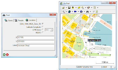
On many handhled GPS devices, you have the ability to "stake out" a point of interest. For example, you may know that you want to navigate to the nearest ice-cream store that has MGA94 coordinates of 527,105 5,251,855. How do you do this in ArcPad I hear you ask?
- Use the Find tool, and switch to the Location Tab.
- Make sure you change the coordinate system to what your coordinates are in (in this case MGA 94)
- Enter the coordinates of the location, specify the label on the map
- Click OK. The mark will be added to your map.
- Activate your GPS, open the GPS position window, and you will be given a bearing and a distance to travel in to reach your destination.

No comments:
Post a Comment