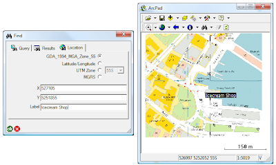
- Use the Find tool, and switch to the Location Tab.
- Make sure you change the coordinate system to what your coordinates are in (in this case MGA 94)
- Enter the coordinates of the location, specify the label on the map
- Click OK. The mark will be added to your map.
- Activate your GPS, open the GPS position window, and you will be given a bearing and a distance to travel in to reach your destination.
Tuesday, December 23, 2008
How can I "stake out" points in ArcPad?
GPS Tracklog - Tips and Tricks
How is it stored?
The GPS tracklog is stored as a point shapefile. Each point contains information such as the time, coordinates and quality estimates. ArcPad represents this shapefile as a line layer, which is what you see in the map when it is turned on.
Where is it stored?
By default, the GPS Tracklog is stored in My Documents. You can alter this from the GPS Tracklog Layer Properties, which can be accessed via the table of contents in the same way as any other layer.
When is the tracklog created?
The GPS tracklog is created when it is needed. If the shapefile is not present and the tracklog is turned on, it will automatically be created.
How do I start tracking?
Select Tracklog from the GPS drop down menu when your GPS is activated.
How do I clear the tracklog?
Stopped for a coffe and need to hide it from the boss? You can clear the Tracklog by clicking the Clear button from the Layer Properties of the Tracklog layer.
Can the tracklog log without showing in my map?
Yes. Open the Table of Contents, and you can toggle the visibility of the tracklog. Behind the scenes, ArcPad will keep logging positions.
What can I do with the tracklog at the end of the day?
As the tracklog is a shapefile, you can copy it off the device and store it back in the office. You could even create a Geodatabase, and store each day's log in there.
Tuesday, December 16, 2008
What is the RMS Error?
The RMSE is a measure of the differences between the predicted or calculated values and the actual, or observed/measured, value. Each individual difference between the calculated and actual value is called a residual. The RMSE aggregates the residuals into a single measure.
The RMSE is derived by squaring the differences between the actual and calculated values, adding these residuals together, dividing that by the total number of values, and taking the square root of the result.
Optimising PDA battery life
Optimising the battery life of your Mobile Device increases the efficiency of your Mobile GIS System. Here is a list of some of the modifications you can make to your Mobile Device to let you make the most of your time out in the field.
Power
Start/Settings/System/Backlight
Cycle through and set options for Battery Power, External Power, Brightness, Keypad Battery e.g. turn off backlight if not used for x minutes, set the screen brightness
Start/Settings/Power
Monitor and select power settings for your Mobile Device e.g. turn off device if not used for x minutes
Start/Settings/Power/Calibration
Check battery calibration status, and re-calibrate battery if recommended (only available on selected devices)
Memory
Start/Settings/Memory/Main
Monitor the free/available memory on your device.
Start/Settings/Memory/Running Programs
Monitor running programs and stop programs that may be churning up memory e.g. ActiveSync, Email, etc
Connections
Start/Settings/Connections/
Monitor the integration of your Mobile Device with other devices through Bluetooth, Wireless Manager and other Connection options, e.g. maintain Bluetooth connection when device is turned off, turn on/off Bluetooth and Wireless connections.
Thursday, December 4, 2008
Transferring photos from Ricoh cameras via BT
So that no one else has to stoop as low as I did and have to read the user manual, here is how you set up the Ricoh / iPaq to give the option to transfer photos via BT immediately after it has been taken.
Make sure BT is switched on on the iPaq
Configure the iPaq to receive the images
- Open the Bluetooth settings (Start -> settings -> Connections -> Bluetooth)
- Switch to the Services tab
- Select File Transfer
- Turn off “Authorization Required” and “Authetication (Passkey) required”
- Hit Advanced, and specify the folder to store the images to
Enable QuickSend on the Ricoh
- Press the [Menu OK] button
- On page 3 of the EXP SET page, change the quick send method to “1TOUCH”
Establish a BT connection between the Ricoh and the iPaq
- Press the [Menu OK] button
- Go to page 2 of the EXP SET page
- Select BT SERIAL, then click Right
- Click [ADJ] to search for devices in range
- Select your iPaq and press [MENU OK]
- Exit out of the menu – you should see the BT icon on the display
Send a photo to the iPaq
- Take a photo
- Hit the PLAY button
- Press [MENU OK] button, and switch to the 2nd page of the PLBK STGS menu
- Click RIGHT on the FILE SEND option
- Select your device
- Click SEND ONE
You will see a dialog on your iPAq confirming that you want to accept the image From now on you get the option to send the image when the quick review is displayed after an image is taken
- Click [OK MENU] during the quick review to send the image
- You will need to confirm the transfer from the iPaq also
Note that you can get the ricoh to establish the BT connection when it starts up by selecting [BT AUTO CONN] on the 2nd page of the EXP SET menu.
Monday, December 1, 2008
Bluetooth GPS Vs CompactFlash GPS - Which one suits me?
Compact Flash GPS
Pros
- Fits into the CF Slot of your PDA/UMPC/Laptop to make an ‘all-inclusive’ unit
Cons
- Limited to integrating with devices with a Compact Flash slot
- The battery of your Mobile Device is used to power the CF GPS, resulting in the battery life of your PDA/UMPC/Laptop dropping by up to half its standard lifespan
Bluetooth GPS
Pros
- Has its own battery independent of your PDA/UMPC/Laptop, so the battery life of your mobile device is not compromised
- Adaptable nature of Bluetooth allows integration with an increasing number of devices (e.g. PDA, Camera, Mobile Phone, etc )
Cons
- May be another piece of equipment to worry about in the field in addition to your mobile device (albeit a very small piece)
Thursday, November 27, 2008
Subtypes and Domains. What is what?
Domains
Domains are rules that are applied to individual attributes that define the possible values for that property. There are two types of Domains in a Geodatabase: Range domains and Coded Value Domains.
Range Domains, as the name suggests, enforce a valid range of numerical values for an attribute. For example, an Age attribute for a Person feature class could be restricted from 0 to 100, meaning that all values between 0 and 100 are valid.
Coded Value Domains enforce a fixed list of values on a field, on any text, numeric or date field. These can be thought of as a look up table, as you can have a different code (the value that is actually stored in the field) to the description (the value that is displayed to the user when entering data). For example, a cadastral parcels feature class may have a zone property defining whether the property is residential (zone 1), commercial (zone 2) or industrial (zone 3). Coded value domains allow you to store the zone number, but display the more meaningful description to the users.
Subtypes
Subtypes are a sub-category of features in a feature class, that all share common properties (attributes). For example, you maye have a feature class of Animals, which you wish to categorise into species. In this case, the species would be the subtype.
The advantage of using subtypes is that you can specify different domains based on the subtype. Using the animals example again, you may have a height attribute with an associated range domain. You would most probably want a different range domain for elephants than for mice. Subtypes allow you to do this.
Subtypes and Domains in ArcPad
The good news is that since the release of ArcPad 7.1 and the new AXF file format, ArcPad directly supports subtypes and domains. This way all of your Geodatabase rules can be enforced at the time of collection in the field, making the data migration process from the field back to the office all the more easier.
GIS Acronyms & Dictionary
There are a number of online resources and GIS dictionaries which define these terms.
A few of these online resources are:
- As part of the Knowledge Base on the ESRI Support Site, ESRI offers a comprehensive GIS Dictionary.
- The Association for Geographic Information (AGI) has a Free Edition of their AGI GIS Dictionary.
- UC Berkeley Library has a Dictionary of Abbreviations and Acronyms for GIS, Catrography and Remote Sensing.
Monday, November 24, 2008
Don't forget the shapefiles!
The table below shows a comparison of the drawing time for the Riverside Parcels sample dataset that comes with ArcPad 7.1 on a HP iPaq 2790. This layer has a total of 3800 parcels. All times are in seconds.
So for any background datasets that are not being edited in the field, you are far better off exporting them to shapefiles rather than AXF.
Shapefiles can easily be exported using the Get Data for ArcPad wizard in the ArcPad Data Manager tools for ArcMap. The one way arrow (check out only) makes a read only shapefile; the two way arrow (check out and in) creates an read and write AXF file.
Thursday, November 20, 2008
Map Scales - Which is Which
Associated with a map is a map scale.
The scale is the ratio of a unit of distance on the map to the equivalent distance on the surface of the earth. (For example 1:25,000 means that 1 cm on the map represents 25,000 cm on the ground, or 250 m).
A map scale is usually represented as a Ratio (1:25,000), but it can also be represented as a Fraction (1/25,000).
Maps are referred to as either 'Large Scale' or 'Small Scale' maps, which tends to cause a fair bit of confusion. Which scale is which?
Large Scale:
- The features represented on the map appear larger. (The map covers a smaller extent of the earth).
- The map scale, when represented as a fraction, is larger. (For example 1/1000 is a larger fraction than 1/50,000).
Small Scale:
- The features represented on the map appear smaller. (The map covers a larger extent of the earth).
- The map scale, when represented as a fraction, is smaller. (For example 1/1,000,000 is a smaller fraction than 1/50,000).
Thursday, November 13, 2008
.GPX - GPS eXchange Format
The GPS eXchange Format is an XML based file format used to describe GPS data. GPX data can be seamlessly transferred between GPS’s and applications that support the format.
Further information about the GPX format can be found at:
The GPX format is supported by a range of applications, including:
- Safe Software's FME - Commercial Software
- Global Mapper - Commercial Software
- OziExplorer - Commercial Software
- GPSBabel - Freeware Utility
- GPS Utility - Freeware Utility
GPS eXchange Format and ArcGIS
A range of third party applications, including those listed above, can be used to convert .GPX files either directly to shapefiles (or GeoDatabase feature classes in the case of FME), or to a text format which can then be converted and loaded.
In ArcGIS ArcMap:
Within ArcGIS the .GPX format is supported using the Safe FME ArcGIS Data Interoperability Extension. Information about the formats supported is available from both Safe Software and ESRI.
The ArcPhoto Extension, which can be downloaded from the ESRI ArcScripts site, includes support for the upload of GPX Data, from a GeoProcessing Model. Further information can be accessed from ESRI ArcScripts, and search for either 'GPX' or 'ArcPhoto'.
In ArcGIS Explorer:
ArcGIS Explorer has native support for the import of .GPX data from the Tools > Import Menu.
Furthermore, a custom task, the GPS Data Manager, can be accessed and downloaded from the ESRI ArcScripts site enables the upload of GPX Data. Further information can be accessed from ESRI ArcScripts, and search for 'GPX'.
In ArcPad:
Within ArcPad .GPX data converted to Shapefile format, or data that has been checked out into AXF format, can both be utilised.
Usually ArcPad is configured to communicate directly with a GPS receiver. The data is streamed using a specific GPS Protocol and the spatial features are captured using the GPS location from within ArcPad. Features are stored in either a Shapefile or AXF feature class, and can be synced (checked in) and converted from within ArcGIS.
Friday, November 7, 2008
Movember Madness
Welcome to the RIA Mobile GIS Blog. Here we will keep you abrest of all the coming and goings in our world of Mobile GIS. But to start things off we decided sign up to Movember to help raise funds for men's health issues. Unfortunately we have no before photos but by the end we hope to some mighty moe's for you all to see.
If you would like to donate to this cause follow this link.