Monday, March 30, 2009

ArcPad Tips & Tricks #2: Multiple layer definitions

Did you know that the AXF file format supports multiple layer definitions for a single feature class? This works in the same way as Layer files in ArcMap: the layer defines the symbology, which points to a feature class, which stores all of the data (both spatial and attributes). To set this up in ArcPad:
  1. Open the AXF in ArcPad studio
  2. Expand the Feature Tables node
  3. Right click on the table you wish to create the layer definition for, and select "Create New Layer". A new layer definition is added to the Feature Layers node
  4. You can rename the layer to whatever you like

And how is this useful I hear you ask. Well, a couple of ideas are:

  1. You could create different edit forms for different purposes. For example, you may have a layer for new features that are collected, and one for follow up inspections. You can specify different forms to ensure the correct fields are filled out in each inspection.
  2. You can combine the layer definitions with filters to create more complex symbology. For example, you may wish to categorise your roads layer into suburban roads, major roads and highways, and display them at different zoom scales.
Wednesday, March 25, 2009

ArcPad Tips & Tricks #1: Layer Icons


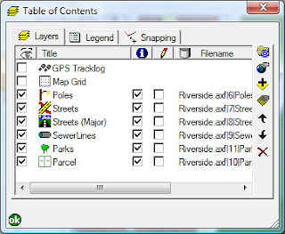
Did you know that you can set icons for your layers. These will appear in the Table of Contents and the Edit drop down menu, making it easier to differentiate between your layers.


For shapefiles, all you need to do is copy a .ico file, with the same base name as the shapefile, into the same directory. So, for example, if your shapefile is Roads.shp, name you .ico file Roads.ico.

The process is a bit more complicated with AXF files. You need to open up the axf in Application Builder, right click the layer and select "Set Layer Icon". You can clear the icon by selecting "Clear Layer Icon".

A good selection of sample icons can be found in C:\Program Files\ArcPad 7.1\Samples\Layer Icons. If you want to make your own, a good program is IcoFX. Your icons need to be 4bit 16x16 images.

Tuesday, March 17, 2009

Behind the Scenes Technical Assistance

In the wake of the recent Victorian Bushfires, behind the scenes, staff from RIA Mobile GIS have been providing technical assistance to MapTel, to support the Victorian Police Search and Rescue efforts.

For further information read the post ArcPad 8 - Victorian Bushfires 2009 on the MapTel Blog.

Monday, March 16, 2009

Mobile GIS Image Capture

There are a number of different hardware options to choose between for image capture within your Mobile GIS System. The competing priorities of specifications, cost and usability are balanced to determine the choice made by the user. Here is a table listing some of the typical units used for Mobile GIS applications and their respective camera specifications:


IPAQ 612c Business Messenger
· Reasonably priced non-rugged unit with PDA/GPS/Phone, suited to users requiring an all inclusive device.
· Typical applications include
Asset Management: recording and monitoring assets in urban streetscapes

TDS Nomad 800LC*
· Rugged (IP67 rating) all inclusive PDA/GPS/Camera unit with long battery life, suited for tough outdoor environments
· Typical applications include
Asset Management: street/pavement inspection, maintenance and repairs
Environmental Monitoring: Tree inventories, pest control, weed management

* Now also available in the 800XC model, which includes all the 800LC specifications in addition to GPRS and 2GB Flash Storage. Contact RIA Mobile GIS for more information.

RICOH Caplio 500SEW Camera
· Rugged (IP67 rating), stand alone camera that can be utilised for a wide range of applications. BT/WiFi included, allowing easy connection to your Mobile GIS System and transfer of images in the field. RICOH clip on GPS module or Digital compass/GPS module also available. Includes CALS mode which has default settings where captured images are suitable to be submitted for official public works.
· Typical applications include
Asset management: Construction/Engineering firms recording images of defects
Insurance Companies: Image records for insurance claims

Friday, March 6, 2009

RIA Mobile GIS Expands Training Courses

RIA Mobile GIS now offers an expanded range of Training Courses.

These courses are designed to assist organisations and users achieve the most from their Field Project. The courses are designed to encompass both the Field and Office (Desktop) components of a field based project as well as cover the integration between these components.

The Mobile/Field based courses are:

  • Using ArcPad - 1 day course providing a functional overview and hands on experience using ArcPad and associated hardware.
  • ArcPad Application Builder - 1 day course providing a functional overview of how ArcPad Studio can be used to customise ArcPad and extend its’ capabilities.

RIA Mobile GIS is an ESRI accredited trainer authorised to provide ArcPad training courses. We are the developers of the ArcPad and ArcPad Application Builder courses run throughout Australia and New Zealand.

The Desktop/Office based courses are:

  • Introduction to ArcGIS - 2 day robust course providing a conceptual overview and hands-on experience using ArcGIS Desktop software.
  • Using GeoDatabases - 1 day course providing an overview and hands-on experience using the ArcGIS GeoDatabase format.

All Courses are offered as either Standard Scheduled Courses, or Client Requested Onsite Courses.

Please note that our training options will be further expanded, updated and refined over the coming months with the impending release of ArcPad 8, which is due out shortly.